Tonight on Google Earth, I noticed that the towns and cities in North America have a similar street pattern. It probably has to do with the history of its origin. In the Netherlands and Belgium, for example, the villages and towns look very different from above. Still, I wonder why this happened. After all, when Columbus discovered America, there were no cars yet.


Answer
Dear Theo,
That is indeed well noted. The plan with straight streets is typical for newly founded cities that have been laid out according to plan, not only in America but all over the world.
Ever since the first cities arose, efforts have been made to lay them out as systematically as possible, especially for new foundations. Just look at the Inca cities or how the Romans in our regions try to structure their cities in a checkerboard pattern.
When cities were built all over America under European influence, a similar structure was also built there in the new foundations. In this way, development often starts from a central axis that is also an important (through) road for the settlement. Think e.g. also to the image of a western village.
With further development, more and more parallel streets were added, which eventually yield the typical checkered pattern.
However, when a city grows organically from an older settlement, they do not have such a tight organization. For example, many European cities have grown (concentrically) around churches, castles and other important landscape elements. Their shape is therefore more like a spider web with a tangle of streets. Sometimes this tangle was erased during the development of a city by renewed urban planning and the shape became more rigid.
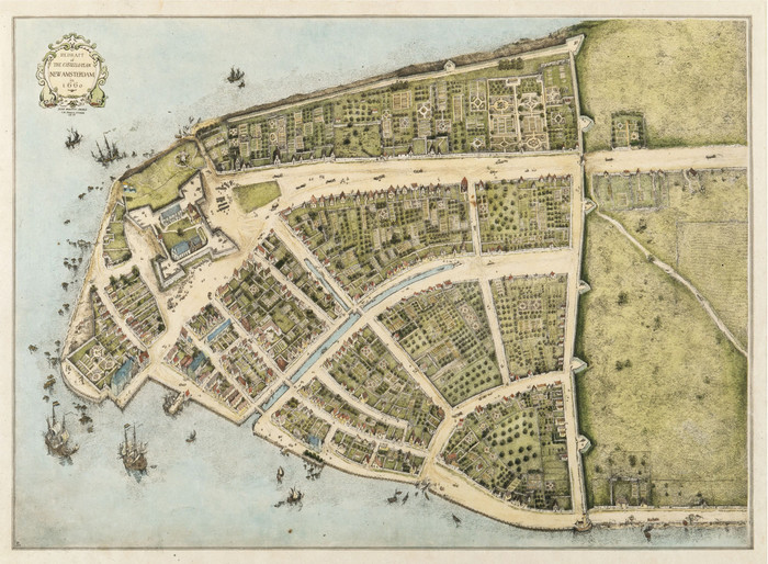
You gave the map of New York yourself, whereby the latest urban development (on the right on your figure) does have the characteristic checkerboard pattern. However, the historic core of the city is to the left of the jutting point in the water. When the Dutch founded the city and named it New Amsterdam, the first settlement looked even more organic. Have a look at the added historical map of New York. That looks a lot more like what we are used to from some villages and towns, doesn’t it?
Hopefully I have answered your question sufficiently.
Sincerely, Tim Clerbaut
Answered by
PhD student Tim Clerbaut
archeology archeology

http://www.ugent.be
.