Google Maps allows you to view floor plans and satellite photos. It is a useful site for looking up addresses and planning routes. For some time now you can even look up the local weather and traffic information.
Step 1: The overview map
The opening page of Google Maps shows a map with a number of navigation options. In addition to this map view, Google Maps also offers a satellite photo view.
You can activate the satellite photo view by clicking Satellite. The button at the bottom left is now called ‘Map’. When you click it again, the map view becomes active again. This way you can switch between the two views at will.
Step 2: The Other Features
Around the overview map you will see all kinds of other options and buttons. At the very top is the search bar. You can enter an address there. To the right of the search bar is an arrow icon. That is the option ‘Directions’, with which you can plan a route.
At the bottom right of the map are an orange man and a plus and minus sign. The orange man is for the StreetView function, which you will read more about later. The plus and minus signs allow you to zoom in and out on the map.
.png)
At the top left of the search bar you can click on the image with the three stripes. By clicking on this, some options become visible:
- ‘Satellite’. Clicking on this activates the satellite photo view.
- ‘Terrain’. If you click on this, you can view the height and depth differences of the landscape.
- ‘Traffic’. If you click on this, you will see current traffic information. You can read more information below.
- ‘Bicycles’. This shows you bicycle routes, cycle paths, bicycle-friendly roads and unpaved paths.
- ‘Share location’. Allows you to share your current location with others. You must be logged in for this.
- ‘My places’. Allows you to view the places you have saved or visited.
- ‘My contributions’. Here you can view your uploaded photos and read information about how to place photos on the map.
- ‘My timeline’. View the routes you have taken.
- ‘Share or embed map’. Allows you to copy the hyperlink of the ticket from a specific location. For example, to put on a website or to forward it to someone. You will be given the option to do this via email.
- ‘Print’. Print the directions on paper.
- ‘Search Settings’. If you are logged in with a Google account, you can save your location data here. This can be useful to calculate a route directly from your current location. You can also choose not to do this for privacy reasons.
- ‘History’. If you are logged in with a Google account, you can see what you have searched for here. Within the search engine Google and Google Maps.
Step 3: Find address
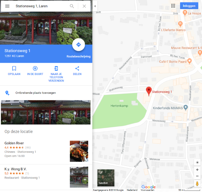
Finding an address is easy with Google Maps. Type all the data you have into the search bar. Separate the address and place of residence with a comma. You do not always need complete address details: ‘Stationsweg 1, Laren’ will be found, but also ‘Stationsweg, Laren’. You don’t need to know the address of bus and train stations: just type ‘bus station’, Utrecht’ or ‘central station, Utrecht’, and Google will find it. To start the search, press Enter key after typing or click the magnifying glass button.
Sometimes Google thinks there are multiple results for the search. While typing an address, all possible search results appear as a list below the search bar. You can click on the correct result to go there. Google may also find multiple results after pressing the Enter key or the magnifying glass button. The results are indicated with a red icon. You can go there by clicking on the icon.
Step 4: Plan route
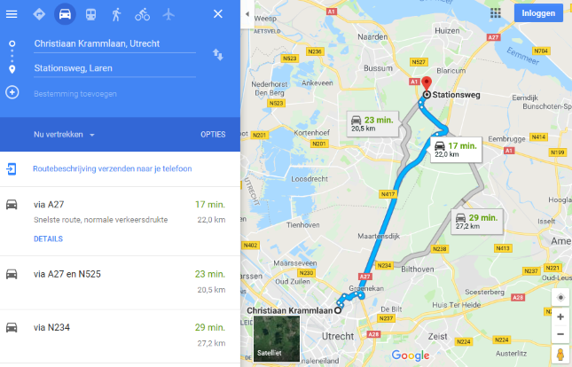
In Google Maps you can plan a route by clicking the ‘Directions’ icon to click. Planning a route with Google Maps does not differ significantly from the procedure in other online route planners: you enter a start and end point and Google Maps shows you the route. What is special is that you can choose from a car route, a public transport route, a walking route, a bicycle route and a route by plane. In this way you can also plan a nice city walk, for example. You plan a route (by car) as follows:
- Click on the button with the picture of the car.
- Enter your departure point at ‘Choose a departure point or click on the map’. Instead of typing the address, you can also click on the departure point on the map. The address will then be entered automatically.
- Enter your destination at ‘Choose a destination or click on the map’. You can also click on the destination on the map.
- Press the Enter key on the keyboard.
The possible routes are shown on the map and as a list below the search bar. The selected route is shown in blue on the map. If there are other possible routes, they are shown in gray. You can select a different route by clicking on it on the map or in the list below the search bar. You can view the textual directions by clicking below the search bar on Details. Click on a number next to the text description to zoom in on the map on the corresponding part of the route.
street view (1)
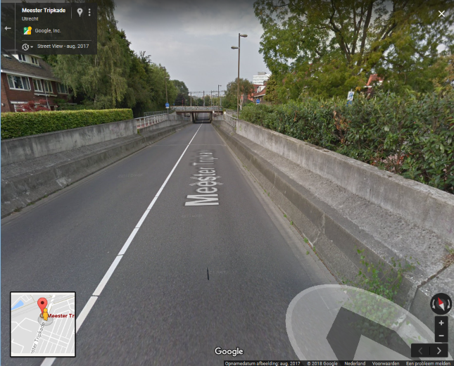
Streetview is English for ‘street view’ and this is a good description of this part of Google Maps. It allows you to ‘walk’ through a 3D environment as if you were actually in a certain location. You can ‘walk’ down a street in another city and look around. This function stitches photos together to give a realistic depiction of a particular environment. The function can be used in most major cities in the Netherlands. Very useful if you want to get an idea of a certain environment before you actually go there. This is how this works:
- Look up an address.
- Click on the picture of the orange man and hold down the left mouse button.
- Drag the man to the location you want to view.
- If Streetview is active there, you will see thick blue lines drawn in the map.
- Release the mouse button to place the male on the location.
- Streetview opens and you see the 3D environment.

street view (2)
Within Streetview you can ‘walk’ and look around you. If there are more photos of a street, you will see an arrow when you hover over the street. Click where an arrow is visible to move in that direction. You look around you with the mouse. Click anywhere on the map and hold down the mouse button. Then move the mouse left, right, up or down. The map moves with you. When you are done moving, release the mouse button. This way you can turn around within Streetview and go the other way, as it were.
At the bottom left of the image is a small part of the map. With that you can orientate yourself a bit. You close this view by clicking on the gray arrow at the top left of Streetview, next to the address. Then you return to the normal map.
Traffic
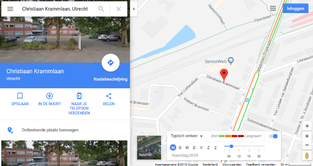
Also view the weather and traffic information in Google Maps. You first look for a location or route for which you want to know this information. Then click in the menu bar on the image with the three stripes. Then click Traffic and the traffic information is drawn on the map itself. The color red on a certain road indicates that there are traffic jams and with green everything goes smoothly. You can choose whether you want to see how the traffic is right now or how it is in general. Click at the bottom of the page for this Live traffic information and select Live traffic information or Typical traffic. If you choose ‘Typical traffic’, you can indicate from which day and what time you want to see the typical traffic situation. To turn off the traffic function, click the image with the three lines again and then click Traffic.
Finally
Google Maps is a handy site that you can have a lot of fun with. Just try out all the features at your leisure and see which options you like best. Not everyone will feel the need to use everything, but the options to look up an address or plan a route are certainly very handy.