 Plan a bus, train or tram journey on your smartphone with Google Maps.
Google Maps
Google Maps allows you to view floor plans and satellite photos. Many people use the Street View component to see what a street or building looks like. In addition, Google Maps is often used as a route planner. The program can create routes for the car, public transport (public transport), bicycle and for walkers. You can plan a route on the PC and in the app on the smartphone.
Enter departure and arrival point
Planning a route starts with entering the departure and arrival location. It is not necessary to know the exact address. Enter street and place names, but also, for example, the name of a square, station, building, restaurant, amusement park or tourist attraction. For example ‘Anne Frank Huis’, ‘Dental Practice Jansen Maastricht’ or ‘Bus stop De Stier Amersfoort’. As an example, we travel from the SeniorWeb office in Utrecht to Maastricht station.
- Open the Google Maps app.
- At the bottom right of the overview map is a blue circle with a white area and a blue arrow. Tap this.
- Tap the “My Location” box.
- Type a starting location. This is the starting point, for example your home address or the nearest bus stop.
- Suggestions appear as you type. Is the desired departure location listed? Tap it. Or type the full name and tap the magnifying glass on the keyboard.
- Tap the “Choose your destination” box.
- Enter the desired arrival location.
- Suggestions appear as you type. Is the desired destination listed? Tap it. Or type the full name and tap the magnifying glass on the keyboard.
Google Maps layout
Now that the departure and arrival points have been entered, the screen consists of four parts:
- At the top are the departure and arrival locations.
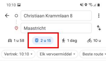
- Below that is a bar with possible means of transport: the car, public transport, the legscart and the bicycle.
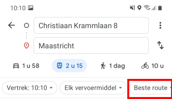
- Below that is a bar with three pull-down menus: departure, means of transport and best route.
- Below are the available travel options.
Adjust mode of transport
Indicate with which means of transport you travel. In this case, public transport.
- In the bar with possible means of transport, tap the icon of a train. This is between the car and the walker. Next to the icon is the duration of the journey in hours and minutes. For example, ‘2 o’clock 11’.

- Although the icon is a train, buses, trams, metros and other public transport modes are also included in the journey. Don’t you want to see them all? Tap the drop-down menu that says ‘Any mode of transport’.
- Tap the checkmark for a mode of transport to no longer see it. For example, switch off the ferry by clicking the checkmark in front of Ferry to tap.
- Accidentally switched off the wrong mode of transport? No problem. Tap the box in front of the asset to turn it back on.
Change departure time
By default, Google Maps thinks you want to leave immediately. Isn’t this so?
- Tap the drop-down menu that says “Departure: [tijdstip]’.
- A window will appear with more options at the top: Departure at, Arrival at and Last. The selected option is colored blue.
- Tap on Departure Om to adjust the departure time.
- Swipe over the hours and minutes to choose a different time.
- Tap on Set up.
- Not traveling today? Tap on Today and select another day on the calendar. Tap on OK > Set up.
- Tap on Arrival at to select an arrival time. This is useful if you have an appointment and want to know what time you have to leave home to be on time.
- Swipe over the hours and minutes to choose a different time.
- Tap on Set up.
- Not traveling today? Tap on Today and select another day on the calendar. Tap on OK > Set up.
- Tap on Last to choose the last possible train, bus or tram of the current day. This way you know what time you can travel to or from home at the latest.
Select route option
Google Maps shows the possible trips at the desired time. At the top is a recommended route. This is the route that best suits the desired departure or arrival time. Adjust this if necessary, for example if you prefer to see wheelchair-friendly routes or if you want to switch as little as possible.
- Tap the drop-down menu that says ‘Best route’.

- Tap one of the other options: Switching less, less walking or Wheelchair accessible.
- Tap on To apply.
Choose a route
The best travel option is at the top of the possible trips. Tap this, or any of the other options, to learn more about it. The overview that opens contains more information about the journey. For example, how far it is to walk from your home to the bus stop, what time the train leaves exactly and from which platform, how busy it is in the means of transport at that time and where you have to change.
- Swipe your finger from bottom to top to see the full route.
- Tap any part of the route to see more of it. This is useful, for example, if you missed a layover en route. In that case, tap the item after the switch and explore other options.
- Is the route not for today? Then tap Add to calendar and choose the calendar in which to save it, for example the Calendar app on the phone. You will then always find the route on the calendar on the desired date.
- Save the trip by clicking Lock to tap. Have you closed the app and want to view the pinned trip? Open Google Maps and tap at the bottom To go. Tap on the correct trip to view it.