 Google Earth is a fantastic program to view countries and places from the air. And that works without an airplane, with only an internet connection and a browser.
About Google Earth
Google Earth is an application that allows you to visit almost the entire world on various devices, as if you were flying over it in an airplane. Many (larger) cities can be viewed in three dimensions, at street level. There are all kinds of options, from measuring the distance between two places to visiting the deep sea. Even galaxies can be explored with it. Google Earth is available as an app for smartphones and tablets, as a program for Windows and has a version for the browser. We zoom in on that version here. It works most smoothly via Chrome. If you don’t have Chrome yet, read Working with Google Chrome first.
Launch Google Earth
- Launch Chrome.
- Go to the website https://earth.google.com.
- Wait a second. It takes a while for the application to start.
- When a globe comes into view, Google Earth is ready to use.
Keep track
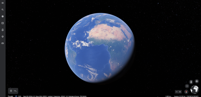
Google Earth is easy to use and has many functions, which are hidden behind the buttons in the image. Holding the mouse pointer over a particular icon displays a brief description of that feature.
In the lower right corner of the screen is a small representation of the Earth. Around it are buttons related to navigating within the program. For example, there are the plus and minus signs to zoom out and in. The doll button starts the Street View feature, if it’s available for a location. Clicking on the compass needle rotates the image to the north. More on navigating with the mouse below.
On the left side of the screen are also all kinds of functions. The button with the three bars opens the menu, which contains almost the same items as in the overview, such as Search, Voyager, Projects and Map style.

Navigate with the mouse and buttons
Exploring the Earth with the mouse is the most convenient way. Click anywhere on the Earth, hold down the mouse button and drag the mouse to rotate the Earth. To zoom in, turn the mouse wheel away from you and towards you to zoom out again. When you are zoomed in far enough, the letter 3D in the button at the bottom right will turn white and you can tilt the image by clicking on it. You will then look at Earth as if you were looking from an airplane or spaceship. Lost?
- Click on the button with the visor at the bottom right
 to fly to your current location.
 - Give Chrome permission by clicking To allow in the browser’s notification.
- Earth zooms out, the earth rotates and you ‘fly’ to where you are (approximately).
Find a place
Are you looking for your own home? Or would you like to take a look around Nice or Moscow? Google Earth finds most places in the world by name. Here’s how to look up (and visit) a place:
- Click the magnifying glass icon (top left).
- The menu will open and a search bar will appear.
- Enter a street name or a place name.
- Suggestions appear as you type.
- Click on the name of the place you are looking for.
- Google Earth rotates and zooms until you see the location you want.
Looking around the streets
Is there a city or village in the picture and are you properly zoomed in? Then try Street View.
- Click on the figure at the bottom right.
- Blue lines appear in places where you can look around from street level.
- The button of the figure is then orange.
- Drag the figure with the mouse to one of the blue lines.
- The environment opens in 3D and you can look around and ‘walk around’ by clicking on the white arrows on the ground.
- Click again on the orange figure to close Street View.
I’am guessing!
A nice feature of Earth is viewing any place in the world. This is done by clicking on the button on the left of the screen, the icon of the five-eyed die  .
.
Google Earth will now open a random spot and usually show some information about it as well. Combine this with Street View (see above) and visit a completely new environment.
Voyager
Voyager is an interesting feature in itself to learn more about our world. Information about, for example, climate change is presented in various ways. Voyager’s components are in English and are therefore not covered in this article.
Lost an overview?
Sometimes it is difficult to see where you are on the earth. Then click on the image of the globe at the bottom right. Google Earth zooms all the way out and you can see the Earth again from space.
Projects
Projects is part of Google Earth to create presentations based on globe markers. That can be interesting to illustrate, for example, a long trip around the world. To use this, you must log in with a Google account.
Measure distance
A popular part of Google Earth is measuring distance between two points. Learn more in Measuring distance with Google Earth.